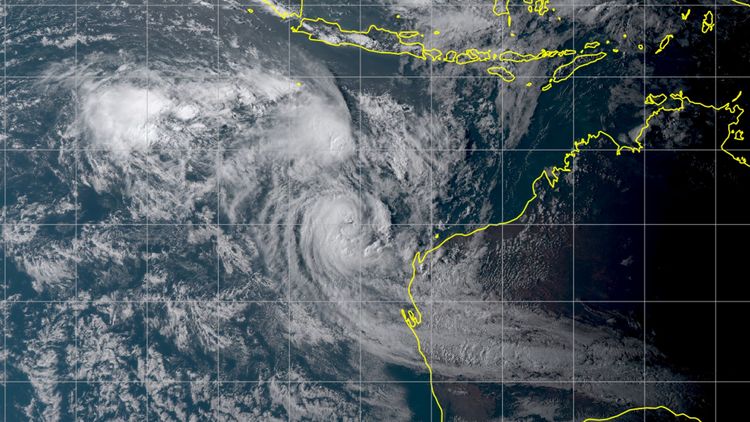
In April 2021, two tropical cyclones, Seroja and Odette, collided in the Indian Ocean northwest of Australia. In a case study, Oliver Wurl and Jens Meyerjürgens investigated how this rare phenomenon affected the ocean.
Tropical cyclones (TCs) not only whip up air masses in the atmosphere, they also churn up water masses in the areas of the ocean that are in their path. When two cyclones collide and merge, these interactions between the ocean and the atmosphere can intensify considerably, as Prof. Dr Oliver Wurl and Dr Jens Meyerjürgens from the University of Oldenburg report in a paper published in the journal Tellus A: Dynamic Meteorology and Oceanography. The two researchers analysed the encounter between two relatively weak tropical cyclones in the Indian Ocean in 2021, TC Seroja and TC Odette, and found that effects occurred that have otherwise only been observed with much stronger cyclones. Since the frequency and intensity of tropical cyclones is increasing as a result of global warming, this type of convergence – and the resulting extreme interactions between air and sea – could become more frequent in the future, the study concludes.
The two tropical cyclones Seroja and Odette came together north-west of Australia in April 2021. To investigate the effects of this unusual rendezvous on the ocean, Wurl and Meyerjürgens combined satellite data and measurements obtained from ARGO floats and autonomous drifters with numerical modelling. These sources provided the researchers with information about factors such as salinity and water temperatures between the sea surface and depths of up to 2,000 metres as well as data about upward and downward (vertical) flow velocities. In addition to these data, they analysed upward and downward (vertical) flow velocities using data from numerical models.
A showdown in the Indian Ocean
The encounter between the two cyclones lasted for around a week. On 6 April they came within approximately 1,600 kilometres of one another. "Seroja first of all stalled the smaller cyclone Odette and then merged with it three days later," reports Wurl, who heads the research group Processes and Sensing of Marine Interfaces at the University of Oldenburg's Institute for Chemistry and Biology of the Marine Environment in Wilhelmshaven. After the two cyclones merged, TC Seroja abruptly changed course by 90 degrees on 9 April. "This chain of events not only influenced weather patterns but also triggered a previously unobserved interaction with the ocean underneath," Wurl explains.
The analysis showed that sea-surface temperatures dropped by three degrees Celsius as an after-effect of the merging of the cylones and that deep, cold water masses were churned upwards towards the surface from a depth of 200 metres in a process known as "upwelling". The cooling effect was "exceptionally high" in relation to the cyclones' intensity, the researchers observed. The highest wind speeds of around 130 kilometres per hour were reached on 11 April, after the merging of the cyclones, and corresponded to Category 1 on the Hurricane Scale. The observed cooling and the depth of the upwelling, on the other hand, were of a scale observed in Category 4 or 5 hurricanes.
Wurl and Meyerjürgens were particularly surprised by the strength of the upwelling: there were periods when the deep-water masses rose to the sea surface at a speed of up to 30 metres per day. By comparison, the typical upward velocity of the ocean is only between one and five metres per day. In this specific case, a downward velocity of the ocean was observed shortly before the cyclones merged. "Thanks to satellite technology and autonomous deep-sea ARGO floats, we were able to demonstrate how the rotation of the cyclones transports cold water from the depths of the ocean to the surface," says marine scientist Meyerjürgens.
Encounters between tropical cyclone are likely to increase
Although encounters between tropical cyclones during their one to two-week lifespan have been rare to date, according to climate models the number and intensity of tropical cyclones is likely to increase as a result of global warming – and by extension also the likelihood of full-blown hurricane-force cyclones colliding. This could result in "the most extreme interactions between the ocean and the atmosphere", the authors of the paper write. The fact that the merging of two cyclones can lead to an abrupt change of course also makes it more difficult to predict how they will behave afterwards.
Wurl also points to another important consequence: "As a result of the interactions of a cyclone with the ocean and the upwelling of cold, deep water, the ocean absorbs additional heat from the air and then transports it to higher latitudes – a crucial process that influences the climate worldwide,". In addition, cyclones also convert thermal energy into mechanical energy which they then transport to higher latitudes as they progress. The two scientists will be taking part in an expedition with the research vessel METEOR in the Mediterranean and subtropical Atlantic next year, during which they plan to further investigate these interactions and the connection with extreme weather events.


