Results
Results
Brief explanation overview
In the following, work results of the individual Work Packages (WPs) are presented. There are three work packages (WP1-3). What is not directly assigned to a work package but to the CREATE work can be found under "Overarching results".
CREATE-related publications are linked under "Publications".
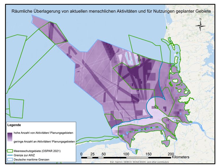
Identify areas where current and planned human activities/interests overlap
Humans are increasingly expanding their radius of action into the sea and pursuing a variety of interests in the German Bight. But not only the area needed for the individual activities is increasing. The intensity of most individual activities is growing and in addition there are new types of activities in the sea. This process means that there is now a wide variety of different human activities with a wide variety of impacts on nature.
WP1 identified spatial hotspots of areas where many current and planned human activities and interests overlap. Areas designated for human activities according to the 2021 Spatial Plan (BSH 2021) (link: here) and data on fishing activities (data: OSPAR 2018) were used as the basis for calculating an index to map this. For each 1km2 grid cell, the respective area fractions of activities were calculated and summed. The following activities were considered: Offshore wind farms, cables and pipelines, major shipping routes, priority areas for fisheries, science, military, resource extraction and conservation, and fisheries.
The resulting map shows that very few areas are not used or designated for the selected human activities . In addition, hotspots were identified where many current and potential human activities and interests overlap. These are located both within and outside of marine protected areas. In interpreting the map, it should be kept in mind that it is based solely on the number of (potential) activities and does not necessarily reflect environmental impacts. Intensity of use was largely not considered in this analysis (an exception here is fisheries data). Similarly, impacts on ecosystem components are analyzed in another paper in the CREATE project.
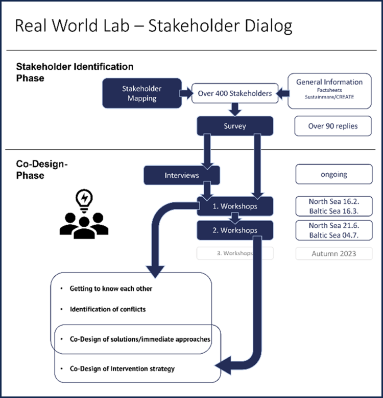
Stakeholder dialogue in the real labs
The stakeholder dialogue in the CREATE project is based on an intensive stakeholder identification phase in which stakeholders were identified through newspaper, internet and document research as well as interviews with already identified stakeholders. In a subsequent stakeholder mapping, the stakeholders were clustered into rough sectoral interest groups. An initial online survey was then conducted to find out how the stakeholders would like to be involved in the project. This formed the basis for further cooperation in the form of interviews and/or participation in workshops. (see figure below...). The survey also included a content part where participants could share, among other things, their impression on the state of the environment, their perception on the biggest negative aspects/developments and their biggest hopes. (LINK - More info here). Information about the workshops can be found here: (LINK - Workshops)
Cooperation with stakeholders in the region - online survey
In order to find out what issues the stakeholders are concerned about, what their impression is of the environmental state of the North Sea and the Baltic Sea, and to get an idea of how they can imagine participating in the CREATE project, WP1 created an online survey. This was sent out from November 2022. In total, 95 of those contacted completed the online questionnaire.
Among other things, it asked:
– In your view, what are currently the biggest negative aspects/developments in the North Sea and Baltic Sea?
– In your view, what are the greatest hopes when you think about the future of the North Sea and Baltic Sea?
Result of the survey: Stakeholders hope for good environmental management as well as a shift in overall societal priorities. Participants also expressed hope based on specific environmental observations, such as an increase in seagrass or confidence in nature's resilience. Conflicting results regarding hopes for the future occurred primarily in the areas of fisheries and offshore wind energy: While some hope for good fisheries management, including through new techniques, others are more hopeful that fisheries as a whole will decline and become less important. Regarding offshore wind farms, some welcome the current development of the expansion and see the associated zero-use zones as an advantage.
On the other hand, the question of problems shows that the expansion of offshore wind farms is also viewed critically. There are also different opinions about the concept of "multiple use": While some see it as an opportunity, others see conflicts of use here in terms of overuse. A classification and quantification of the problems mentioned showed that these are perceived in quite many and different subject areas, with the topics of climate change and eutrophication forming a clear focus.
In the evaluation of the questions on participation in the CREATE project, it became clear that the stakeholders want to participate in a variety of ways. They are willing to give interviews, answer technical questions as experts, participate in workshops, or contribute to the preparation of documents. A few just want to be informed.
Workshops in the real labs
The workshops create a space for joint exchange in which cooperation and understanding of the North Sea and Baltic Sea are to be improved. The collaboration with people involved in the design and use of the North Sea and Baltic Sea in different places and with different activities should serve to shape the future of the North Sea and Baltic Sea as a living, natural and economic space and to reduce the various negative impacts on the environment. Stakeholders from the Sylt Outer Reef and Borkum Riffgrund reallaboratories have already been able to meet in two workshops on the topic of "Sustainable North Sea". Stakeholders from the Eckernförde area were able to meet in parallel in two workshops on the topic of "Sustainable Baltic Sea".
In the workshops the understanding and networking of very diverse stakeholders could be strengthened. This was supported by constructive and respectful discussions and formats that initiated a change of perspective. In addition, competing interests and coordination needs with regard to ecological and social components could be worked out together. Based on a broad understanding of the problem and its causes, relevant topics were named by the group of stakeholders and initial approaches to solutions and areas for action were identified.
Following each workshop, a workshop report was prepared and shared with the participants and interested parties. A possible publication of the reports will be aimed at a later date.
Hydroacoustic investigation to detect anthropogenic traces on the seabed in the Eckernförde Bay
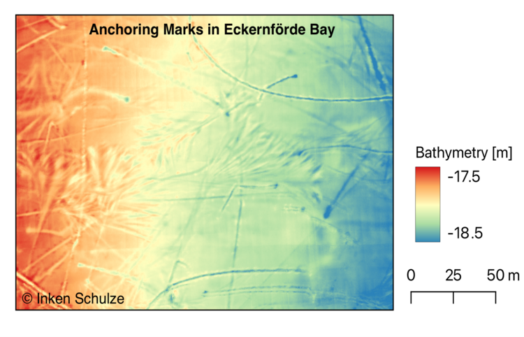
WP 2.2 aims to investigate features of anthropogenic origin on the seabed in Eckernförde Bay, which is affected by activities such as water tourism, fishing and a naval base. The research focuses in particular on answering the following questions:
- Can hydroacoustic methods be used to map anthropogenic physical pressures in Eckernförde Bay?
- Do these anthropogenic pressures have an influence on the local sediment and habitat structure?
The first measurement campaign in the Eckernförde Bay in late summer 2022 aimed to record the diversity of anthropogenic physical pressures on the seabed. Information on the habitat structure and potential physical pressures in the area was obtained from scientific literature and official reports.
During the survey, hydroacoustic data sets were recorded in different habitats such as mud, sand and seagrass beds. A multibeam echo sounder was used to measure data on bathymetry and backscatter strength at two different frequencies. In addition, video recordings were made at certain stations and sediment samples were taken to verify the nature of the seabed.
The first analysis clearly shows anthropogenic traces in both the bathymetry and backscatter data. There are significant differences between the study sites. One area is strongly characterised by furrows and abrasions that can be attributed to anchoring activities (see figure).
Zooplankton and eDNA water samples
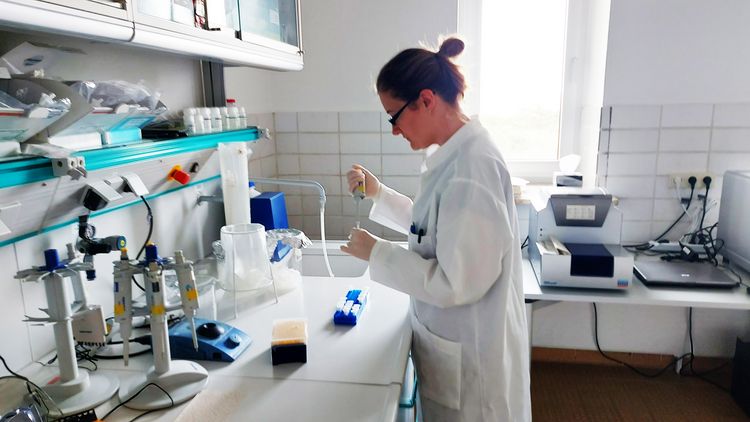
During the cruises around the Borkum reef bottom and the Sylt outer reef, zooplankton and eDNA water samples are collected. DNA is extracted from the collected samples and analysed by qPCR/dPCR to verify the presence of Pacific oysters (Magallana gigas) and European oysters (Ostrea edulis). The same technique could be used in future projects to investigate other species (e.g. lobsters and crabs). In addition, Work Package 2.3 of the CREATE project will assess the overall biodiversity and presence/absence of numerous marine species through high-throughput sequencing (HTS). The picture shows the preparation of samples for dPCR analysis in the laboratories of the AWI Wadden Sea Station in List/Sylt.
Optimization of the classification of hydroacoustic surface data with respect to Habitat dynamics in the substrates of protected marine areas in the North Sea.
Note: Graphics mentioned in the text can be found at the end of the text. Please click on graphic to view in high resolution. (All graphics by: Garvin Breyer and Alexander Bartholomä)
- Acquisition of high-resolution side-scan sonar data with ground-truthing via shipek-grab for the evaluation of multiple classification algorithms
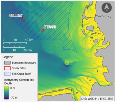
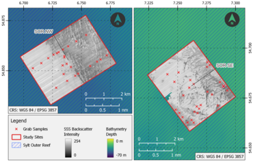
After reviewing and analyzing the existing datasets, additional hydroacoustic surveys as well as grab samples were necessary to evaluate the algorithms for automatic seafloor classification in a suitable way. These surveys and samples were conducted in specifically chosen sites inside of marine protected areas (MPAs). From April 2022 to August 2022, we acquired high-resolution side-scan sonar (SSS) data in one area in the MPA Borkum Reef Ground (BRG) and two separate areas in the MPA Sylt Outer Reef (SOR) (Fig. 1). For every mapped area, 20-30 grab samples have been taken on site and later been thoroughly analyzed in the lab. The study site BRG is characterized by a broad transition zone between open areas of mobile sand layers and areas with increasing block density in easterly direction. The most active area of sediment turnover occurs at the western border of the geogenic reef (Fig. 5). These transition zones with high mobility rates are very important sections regarding habitat dynamics. In contrast to BRG, the study sites in the MPA SOR consist of more heterogeneous small-scale patterns of soft and hard substrates (Fig. 3). The small-scale changes and high spatial complexity make these areas especially suited for algorithm testing. Therefore, the acquired datasets are the foundation for the optimization of hydroacoustic classifications algorithms. All datasets will be published on the PANGAEA database.
- Successful development and evaluation of multiple machine learning algorithms
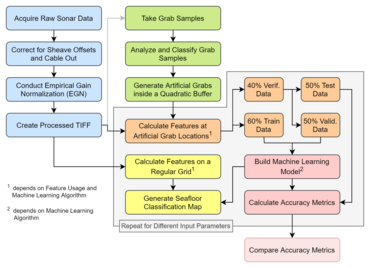
The automatic calculation of sediment maps from hydroacoustic data is of great importance for both habitat and sediment mapping as well as monitoring tasks. There are several approaches for this task in recent literature, which as of now coexist without consensus on particularly suitable methods. Therefore, this subproject aimed to find recommendations for the automatic classification of hydroacoustic data. Random Forests (RFs), Support Vector Machines (SVMs) and Convolutional Neural Networks (CNNs) were used to classify backscatter data of SSS in two study sites located in the Sylt Outer Reef. Already established features such as statistical values and textural features as well as novel features derived from Weyl-coefficients were calculated for different patch sizes (32 px, 16 px, 8 px) and levels of quantization (8-bit, 6-bit). The features were then utilized in the machine learning algorithms; see Fig. 3 for schematic workflow of the overall methodology. Large image patches of 32 px size and the combined use of different feature groups lead to the best classification performances. The level of quantization had little to no effect on the results, thus we recommend using 6-bit quantization to minimize computation time. Further, the CNN and SVM generated visually more appealing sediment maps than RFs despite scoring lower overall numerical accuracy. Especially in transition zones with different sediments, SVMs and CNNs showed superior capabilities of robustly classifying the data. Based on these results we recommend the calculation of image patches of 32 px size and 6-bit quantization for the training of the machine learning algorithms. For the classification itself, the image patches can either be directly utilized in Neural Networks or they can be used to derive the mentioned features that are then provided for the Support Vector Machines.
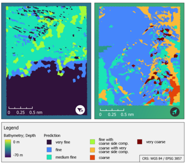
- Automatic classification of study sites in Sylt Outer Reef based on the findings in 2)
Based on the recommendations elaborated in achievement 2, sediment classification maps have been calculated for the study sites located in the MPA SOR (Fig. 4). The classification maps show a high degree of detail while simultaneously minimizing leftover noise. However, transition zones such as in the center of study site SOR NW are still challenging for the algorithms. Moreover, in some areas the classification seems to be ‘unstable’. Where ideally, a larger area would have been classified as the same sediment type, the classification map shows very small-scale patches of differing sediments. These limitations could potentially be tackled by increasing the number of data points (i.e., more ground-truthing) so that the algorithms have a larger amount of information to be trained with. Alternatively, the algorithms themselves could further be improved, e.g. by optimizing the architecture of the neural network. The answering of these questions could be within the scope of the second phase of CREATE.
Ongoing work:
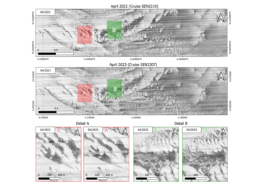
- Investigating sediment dynamics in the MPA Borkum Reef Ground
During a cruise in April 2022, an area of more than 30 km² size was mapped in high resolution with a SSS system in the MPA BRG. The same area should be revisited and remapped in 2023 with additional ground-truthing for an improved classification process. Upon manual examination of the already existing mosaics, changes in sediment can be observed in certain areas, visible through alterations in the "interlocking" of light-dark transitions in the grayscale values. Fig 5A (bottom left) shows a narrowing of the ridges within a year, while slightly further east in Fig. 5B (bottom right), there is a general contrast reduction in the grayscale, resulting in an overall smoothing of the surface relief. With the additional hydroacoustic data and grab samples, our aim is to classify the mosaics from each year and conduct an automatic change detection analysis between the acquisitions. These findings can then be used to better evaluate and understand the sediment (and therefore habitat) dynamics in MPAs.
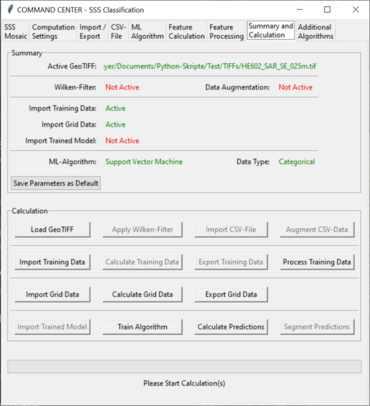
- Implementation of a classification software with an interactive user-interface
The developed software will allow users of hydroacoustic data to calculate their own classification maps. To do this, users will be able to choose between different types of data and different algorithms via a simple click with the mouse. Filtering algorithms as well as preprocessing tools such as feature extraction and feature selection will help homogenize the data sets. The software also automatically saves log-files and is able to export trained AI-models to the hard drive which could greatly enhance the connectivity between researchers, stakeholders and / or agencies. A screenshot of the current state of the software is shown in Fig. 6.
In the real lab: genetic analyses of marine protected area biodiversity and connectivity
Natura2000 protected areas have been established in the German Exclusive Economic Zone (EEZ) of the North Sea to preserve or restore special habitats and their associated fauna. These include the reefs of the European oyster (Ostrea edulis), which have been lost due to human influence and are now to be restored through reintroduction in the Borkum Riffgrund.
We are using genetic methods to test whether the oysters can spread from the restoration sites to other protected zones in the North Sea via their larvae, and thus to assess the network function or 'connectivity' between these zones. We also use genetics to study the biodiversity of the oyster reef itself.
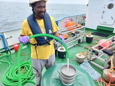
Using molecular genetic techniques, WP 2.3 is assessing the biodiversity of the marine fauna and in particular of the meroplankton, i.e. the planktonic life stages of fish and benthic organisms. In June 2023, we sampled an additional 21 stations for this purpose - on the restored oyster reef and at various distances from it to determine connectivity between Natura2000 sites.
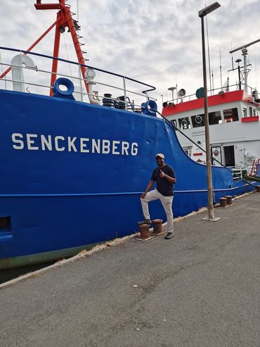
Kingsly C. Beng was able to obtain meroplankton samples for CREATE WP 2.3 on two sea voyages with the research cutter 'Senckenberg' in the two reef laboratories Borkum Riffgrund (BRG) and Sylt Outer Reef (SAR) as well as on a transect in between, which will be analyzed for the presence of oyster larvae. To obtain a sufficient volume of water in close proximity to reef, he used a simple combination of hose and pump.
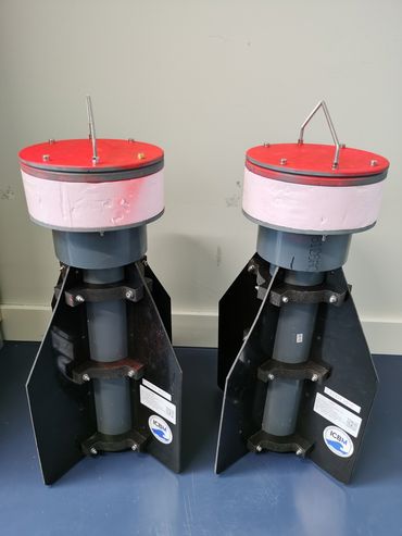
To investigate the possible direction of larval drift during their life phase in the plankton, two drifters were used, which were deployed in cooperation with scientists from the ICBM of the University of Oldenburg. This provides initial data for biophysical modeling in CREATE WP 2.3.
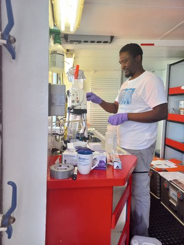
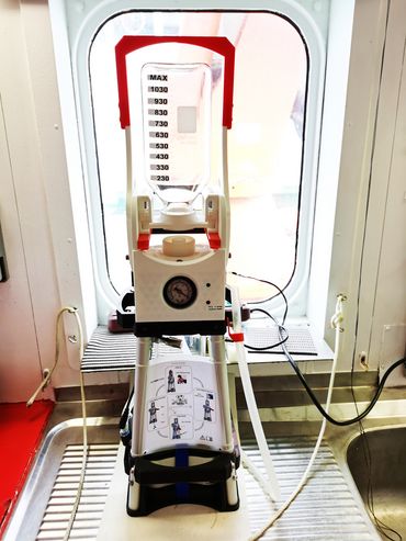
For a non-invasive survey of metazoan biodiversity, we rely on environmental DNA (eDNA), gene fragments in water that originate from excrements or remains of organisms. The "coffee machine", constructed by the Max Planck Institute for Marine Microbiology in Bremen for the CREATE project, allowed eDNA to be extracted from seawater quite conveniently on filters.
Simulations of water transport in the German Bight
Within the framework of WP2.1, AWI is carrying out simulations of water transport in the German Bight under various influencing factors. The numerical tool used is FESOM-C, which was specially developed for resolving the complex dynamics in coastal areas. As an example, the figure on the left shows the transport caused only by the tides, overlaid with the probability map that the currents most often follow this path. This work assesses the connectivity between different sites in the area and thus the likelihood that tracers (e.g. larvae or pollutants) released at one site can reach other sites. As atmospheric influences, together with tides, play a crucial role in the dynamics of the German Bight, several efforts were made to catalogue all types of winds (in terms of direction, duration and intensity) affecting the different areas in the German Bight, from the Borkumreef (the wind rose of hourly wind data at this site is shown in the figure on the right) to the Sylt outer reef zones. The local characteristics of the wind events were also placed in the context of the large-scale atmospheric pressure systems that produced them in order to understand the local variability on the seasonal and interannual time scales that characterise the different sites.
Project meeting on Sylt
On 9 and 10 March 2023, the WP2.3 project meeting took place at the AWI Wadden Sea Station on the island of Sylt. This event provided an opportunity for people working on different topics within the project and in different research institutes (such as AWI, Thünen, MPI-Bremen, Uni-Rostock and HIFMB) to meet in person and discuss recent achievements and future co-operation. Young scientists presented their work and reported on their first results. Part of the time was dedicated to discussing current sampling and analysis methods, future monitoring strategies and planned cruises. The second day of the meeting focused mainly on developing key ideas for phase II of the project.
65 years Boknis Eck
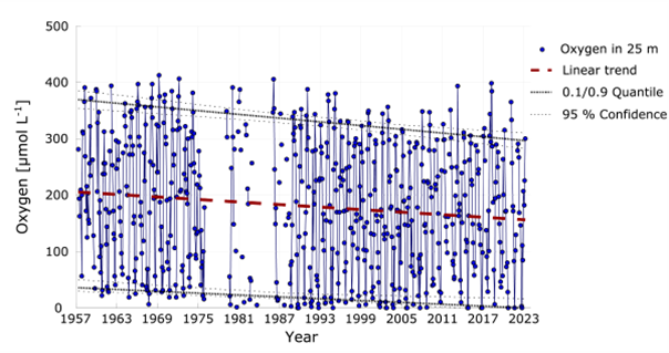
In 2022, the time series station Boknis Eck in Eckernförde Bay celebrated its 65th birthday. The time series station also plays an important role in the Reallabor Eckernförde Bucht. The time series station is coordinated by Hermann Bange, GEOMAR. At www.bokniseck.de and on the new information pages of GEOMAR(www.geomar.de/boknis-eck-zeitserienstation) all important information about the measurements at the station, which also play a central role in CREATE, are listed. The story map prepared by the GEOMAR team(https://storymaps.arcgis.com/stories/e3b2bf799a4a4465937b1b351fa7d0f7) provides an overview of the long-term trends and status of the Baltic Sea and how Boknis Eck can help to better understand the underlying dynamics.
Publication on the release of hydrogen sulphide and methane by microbial processes in Eckernförde Bay
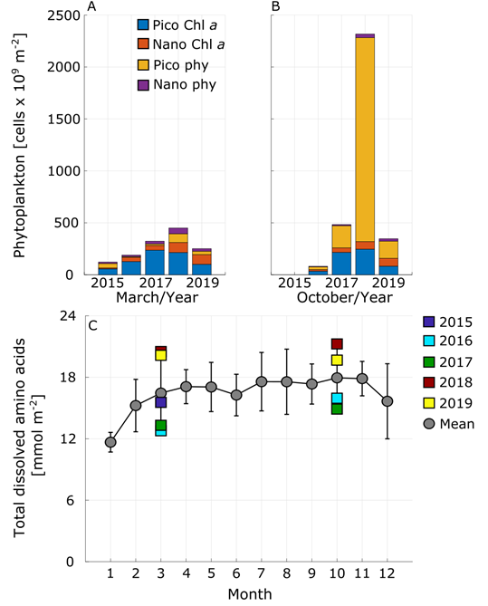
The publication "Environmental changes affect the microbial release of hydrogen sulphide and methane from sediments at Boknis Eck" (with Helmke Hepach, Hermann Bange and Anja Engel from the CREATE project as co-authors) shows how the production rates of hydrogen sulphide and methane by the microbial communities at the sediment-water interface are increased by environmental conditions. For example, an anoxic event in summer 2018 led to a higher release of toxic hydrogen sulphide and the greenhouse gas methane from the sediment into the lower water layers. One reason for the formation of oxygen minima in Eckernförde Bay is the increased formation of algal blooms, e.g. cyanobacteria, triggered by increasingly high temperatures in summer (Figure 1A and B). This increases the content of organic matter in the water column (Figure 1C), which is decomposed by bacteria with increased oxygen consumption. In the event of increasingly frequent anoxic events in the future, this could lead to a greatly increased release of toxic hydrogen sulphide and the greenhouse gas methane into the water column.
Link to the publication: www.frontiersin.org/articles/10.3389/fmicb.2022.1096062/full
Underwater knots soon back in use
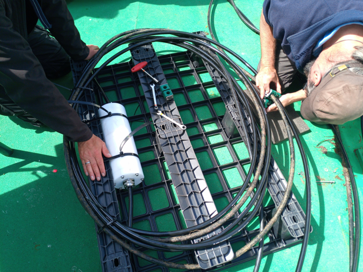
In 2016, a so-called underwater node was released at the Boknis Eck time series station. This can be understood as a "connector strip" for continuous, high-frequency sensor technology. Among other things, the underwater node is equipped with sensors for temperature, salinity, oxygen and microalgae. In 2017, the underwater node was able to detect, among other things, the anoxic upwelling event that led to massive fish kills in the Eckernförde Bay. Unfortunately, the node was stolen in August 2019 and has not been able to record any data since. In May and June 2023, the re-deployment was started. In June 2023, the design of the new cable, which is necessary for both power and data transfer, was successfully completed. In summer 2023, the sensor structure will be deployed and environmental data from the bay will once again be available in live mode.
People and the Sea Conference in Amsterdam
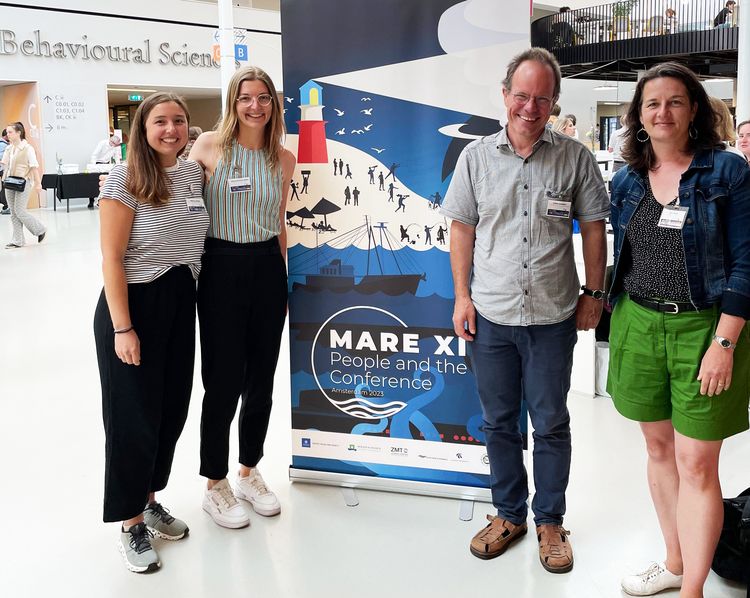
The 12th People and the Sea Conference, organised by the Centre for Maritime Research (MARE) in Amsterdam, provided a platform for scientists from around the world to discuss the theme "Blue Fear: Navigating Ecological, Social, and Existential Anxieties during the Anthropocene". Several scientists from the CREATE project presented their research, bringing pressing marine issues into focus:
Two presentation sessions and a panel discussion on "Perspectives on Ocean Privatisation" were organised by Achim Schlüter, PI. The focus here was on the increasing use of the oceans, which inevitably leads to increased clarification and often distribution of rights of disposal.
Wiebke Homes presented in a panel on compromises in the management of marine protected areas. The question of how to reconcile different uses with nature conservation was widely discussed. In her presentation, the young scientist addressed incentives for more efficient protection of harbour porpoises in the two nature reserves Sylt Outer Reef - Eastern German Bight and the whale sanctuary off Sylt and Amrum.
The panel Community-based and non-governmental approaches to fisheries, on the other hand, looked at the potential and impact of different fisheries management measures. In addition to presentations from France and the USA, junior researcher Jana Katharina Stahl presented her research on the collective action of coastal fishermen in the German Baltic Sea to protect non-target species. The case explores the potential of bottom-up initiatives to reduce bycatch in fisheries and reduce pressure on non-target species.
Only one panel offered the opportunity for a focused exchange on current policy developments in the offshore sector. The presentations from Denmark, the USA and Germany (including Irit Ittner, PI) elaborated on important issues that also arise for German marine governance: a) the safety of infrastructure on and in the sea; b) the governance of innovative infrastructure (energy islands), c) dealing with protests by the affected population (landings of submarine cables, natural gas extraction), as well as d) the politically astute handling of national marine energy development strategies that are not always in harmony (gas policy Netherlands vs. Germany).
Active contribution to the development of the National Marine Strategy

As part of the German government's marine offensive, which was set out in the coalition agreement, a key stakeholder workshop on the development of the Nationalen Meeresstrategie (NMS) (National Marine Strategy) was held at the Bundesministerium für Umwelt, Naturschutz nukleare Sicherheit und Verbraucherschutz (BMUV) ( Federal Ministry for the Environment, Nature Conservation and Nuclear Safety) in Bonn at the beginning of May. The aim of the NMS is to protect and restore unpolluted, species-rich and productive seas whose use by humans is designed in a way that is compatible with nature.
Helmke Hepach (GEOMAR) and Jana Stahl (Humboldt University Berlin), two scientists from the CREATE project, took part. During the workshop, possible goals and measures for five proposed fields of action were discussed intensively with the aim of clarifying responsibilities and identifying concrete implementation paths and suitable measures that go beyond the EU-wide Marine Strategy Framework Directive (MSFD). The prepared proposals for key measures, drawn up by the BMUV and other federal ministries, served as a basis for the discussions.
The discussions in the workshop led to a series of concrete proposals and measures to support the objectives of the NMS. The involvement of CREATE ensured that scientifically sound perspectives were incorporated into the decision-making processes.
The proposals and measures developed in the workshop form a solid basis for the further development of the National Marine Strategy. Close cooperation between science and policy makers and the involvement of scientists in political decision-making processes are important steps towards ensuring the sustainable use of our oceans.
Consultation process Schleswig-Holstein National Park
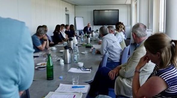
In March 2023, the Ministry for Energy Transition, Climate Protection, Environment and Nature (MEKUN) in Schleswig-Holstein officially launched the consultation process for a Baltic Sea National Park. Scientists from CREATE at GEOMAR Helmholtz Centre for Ocean Research Kiel and Christian-Albrechts-Universität zu Kiel have been involved in this process, both as scientific advisors and as stakeholders. At the "Round Table on Marine Research" (see picture), the plans of the Ministry were discussed with scientists from CREATE, but also from other DAM SustainMare projects. More information on the consultation process: www.schleswig-holstein.de/konsultation-ostsee
Workshop Malta
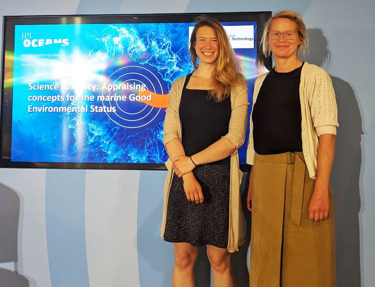
In June 2023, scientists and policy makers met for two days at the Esplora Interactive Science Centre to participate in the JPI Oceans S4GES workshop in Malta. The main objective was to assess concepts for Good Environmental Status (GES) in the marine environment. We, Silke Laakmann and Anneke Heins, thank the Malta Council For Science & Technology for hosting this event and inviting us to the CREATE project. Throughout the workshop, we had the opportunity to have productive discussions on the role of science in addressing GES challenges (Day 1) and on the role of the European Union in shaping environmental policy (Day 2). The presentations covered a wide range of topics, such as the innovative application of eDNA in monitoring campaigns, remote sensing, assessment of pollutants, EU directives on soils, and the complexity of the multi-dimensional and multi-layered marine system, among many other captivating topics.
Status seminar project meeting CREATE at HIFMB Oldenburg
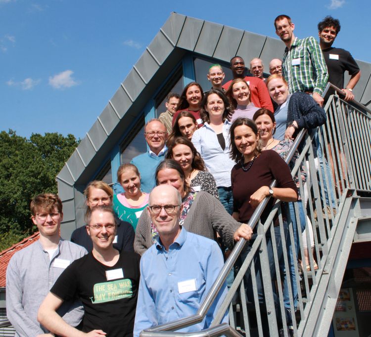
On June 5 + 6, 2024, CREATE met at the HIFMB in Oldenburg,
to discuss the joint work, the first phase and the upcoming second phase of the sustainMare mission on site.