Hydroacoustics
Hydroacoustics
Subproject 1: Holocene science and culture history
Hydroacoustics

Contact: Dr. Alexander Bartholomä
Tel.:+49-(0)4421-9475-210
Viola Stratmann Tel.: +49-(0)4421-9475-218 viola.stratmann[at]senckenberg.de
The sub-project “Hydroacoustics” deals with the reconstruction of the depositional environment of the post-glacial sediments in the Jade Bay. Seismic measurements will be linked to the data of already existing and newly drilled boreholes in a 3-D model. Location of the seismic profiles (see the picture above) in the Vareler shipping channel (profiles in red), the Stenkentief (profile in black) and the Ahne (profiles in blue). The NE to SW trending transect and its cross profile can also be seen (profiles in green and yellow). One focus of the geological interpretation forms the discrimination of the Holocene sequence against the Pleistocene subsurface and the detailed reconstruction of the Pleistocene drainage systems according to the rising sea-level since the end of the last glacial period (8000 BP). In order to evaluate the influence of the currently observed increasing storm occurrences on the surface sediments and to make statements about sediment turnover rates in the future, the current spatial variability of the sediment composition will be mapped with the help of acoustic seafloor mapping.
Methods:
Seismics:
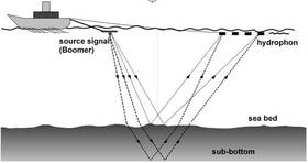 | High-frequency shallow water seismics is a method where acoustic waves are emitted into the subsurface by an acoustic source (Boomer). The waves then are reflected at interfaces and recorded at the water surface. Thus one obtains an image of the subsurface structures.. |
Acoustic seafloor classification:
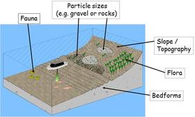 | The acoustic seafloor classification is applied in order to cover the spatial distribution of the surface sediments. The method divides the seafloor into classes of the same/similar acoustic characteristics. In order to precisely define these classes in a sedimentological way, surface samples have to be taken at predefined locations of the scheduled research field. With the help of these samples the sediment classes then can be identified. |