
Increased rainfall and rising sea levels increase the risk of inland flooding in coastal areas: the KLEVER-Risk project shows how western East Frisia can successfully adapt to climate change.
Howling storms, high waves, breaking dykes - these are the images that many people have in mind when it comes to flooding on the North Sea coast. The devastating storm surge of 1962 has burned itself into the collective memory, even among those who did not experience it themselves, thanks to the corresponding images. Since then, no other storm surge in Germany has caused a comparable catastrophe. The dykes, which were renewed and improved after '62, held.
However, this has not eliminated the danger of high water and flooding. On the contrary. "Ever since people started building dykes along the coast centuries ago, excess rainwater from inland areas can no longer drain so easily into the North Sea. This results in the risk of inland flooding," explains Jan Spiekermann. The spatial planner conducts research in Prof Dr Ingo Mose's Applied Geography and Environmental Planning working group at the Institute of Biology and Environmental Sciences. Over the past few years, he has been working extensively on the drainage situation in West-East Friesland, more specifically in the areas of the Emden, Norden, Aurich and Oldersum drainage associations.
Researchers take a look into the future
"We assume that the volumes of water that need to be drained there will increase by up to a quarter in the winter months in future," says Spiekermann. He is the lead author of the recently completed report, which marks the end of the KLEVER-Risk project. On more than a hundred pages, the authors describe the climate changes that the region should expect in around 50 to 80 years and the options that those responsible have to respond to the increasing flood risk. In addition to Spiekermann, his colleague, landscape ecologist Nadine Kramer, as well as researchers from Jade University and employees from the four West East Frisian drainage associations, the district of Aurich, the city of Emden and the Lower Saxony State Agency for Water Management, Coastal Defence and Nature Conservation (NLWKN) were also involved. The project was funded for three and a half years with 300,000 euros from the Federal Ministry for the Environment. It followed on from the previous KLEVER project, which had a similar focus but only looked at the area of the Emden drainage association.
Sea level influences drainage
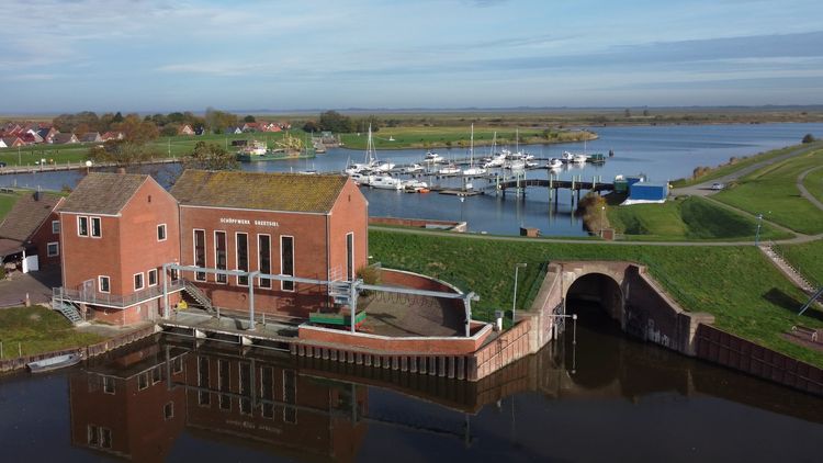
The participants from Jade University used extensive modelling to examine the effects of climate change on the regional water balance up to the year 2100 and used this data to calculate how much water will have to be drained via the vents, depressions and canals in the future. These predominantly artificial bodies of water have been channeling water into the North Sea for centuries. Because the dykes act as a barrier, the water can only pass through them at certain points: at sluice gates and pumping stations. Sluice gates protect the inland from the seawater with sturdy gates. However, if the outside water level is lower than in the incoming water, for example at low tide, the gates are opened and the inland water can flow out into the North Sea.
The rising sea level will reduce the hours in which drainage is possible in this way, in some cases drastically, the researchers have calculated. In the most pessimistic scenario, which assumes a sea level rise of 110 centimetres by the end of this century, the external level at the Knock sluice gate in Emden, for example, could be so high in just a few decades, even at low tide, that it will be virtually impossible to drain.
Infrastructure is reaching its limits - and getting on in years
The reduction in the possibilities for sieving means more work for the pumping stations integrated at the sieve locations. They can pump the water into the North Sea using a great deal of energy. However, the greater the difference in level to be overcome, the lower the drainage capacity of the pumps. However, it is not enough to increase the capacities of the pumping stations, which are not only reaching their limits but are also getting on in years, says Spiekermann. Working closely with local drainage associations, the Oldenburg researchers have developed and evaluated measures to reduce the risk of future inland flooding. Spiekermann favours decentralised solutions. For example, he has identified potential locations along the coast where additional pumping stations could be built together with local experts from the drainage associations. They would relieve the existing ones and also help to partially compensate for the failure of another plant - for example in the event of a power cut.
"Another approach is to keep the water inland for as long as possible and thus relieve the pressure on the pumping stations," explains the spatial planner. The project participants have marked numerous areas on a map as so-called retention areas which, from a topographical point of view, would be well suited to temporarily store large quantities of water. The most prominent example is the Great Sea, a lake between Aurich and Emden, which is already being used as a retention area. If additional shoreline areas there were to be deliberately flooded in the event of an impending flood, this measure could relieve the drainage system of up to one million cubic metres of water. For comparison: To release this amount of water into the North Sea, the Knock pumping station, which is by far the most powerful, currently has to operate for four and a half hours under optimal normal tide conditions.
Water treasure instead of water mortgage
"Storing the water in the area rather than discharging it actually has advantages," says Spiekermann. It could be used during dry periods, which are also increasing due to the climate, to prevent connected water bodies from drying out. "These water reservoirs may even be interesting for the production of green hydrogen in the future," he says, referring to the so-called water electrolysis process, in which water is broken down into its components hydrogen and oxygen. "For centuries, people in East Frisia spoke of a water mortgage. This is changing: we could actually speak of a water treasure."
Nevertheless, floods cannot be completely avoided. This is why the comprehensive report also includes exemplary alarm plans, recommendations for low-risk spatial planning and tips for the population to take precautions themselves, which, according to Spiekermann, is the result of "extremely successful collaboration" between the researchers and local experts. "The project results give those responsible a great head start in adapting to the impending climate changes," he is convinced. They now have the information they need to plan a sensible course of action.


