Lidar & Wakes
Contact
University of Oldenburg
Institute of Physics - ForWind
Dipl. Phys. Jörge Schneemann
Küpkersweg 70
D-26129 Oldenburg
Tel: +49 (0)441 / 798-5066
Email: joerge.schneemann@uol.de

Lidar & Wakes
The remote sensing technique lidar
Lidar (Light detection and ranging) is an established remote sensing technology for measuring the wind flow, used in industrial applications as well as in academic wind energy research. The wind industry mainly uses lidar for resource assessment and power curve measurement. Universities employ lidars for e.g. the measurement of complex wind flows in the direct vicinity of single wind turbines or the entire wind farm. These measurements can be used to improve wind turbine and wind farm efficiency by extending the knowledge about the interaction of wind turbines with the flow.

Measurement of single and multiple wind turbine wakes
When the wind passes through the wind turbine rotor, mechanical energy is extracted from the wind, causing a wake which propagates downstream. An accurate knowledge of wakes, with their characteristic lower wind speeds and impact on downstream turbines, plays a major role in the optimization of the wind farm layout. Information about the position and the propagation of wakes can also be used to optimize the power output of existing wind farms by clever wind farm control strategies. We investigate the dynamic behaviour of wakes and develop computationally inexpensive wake models for these objectives.


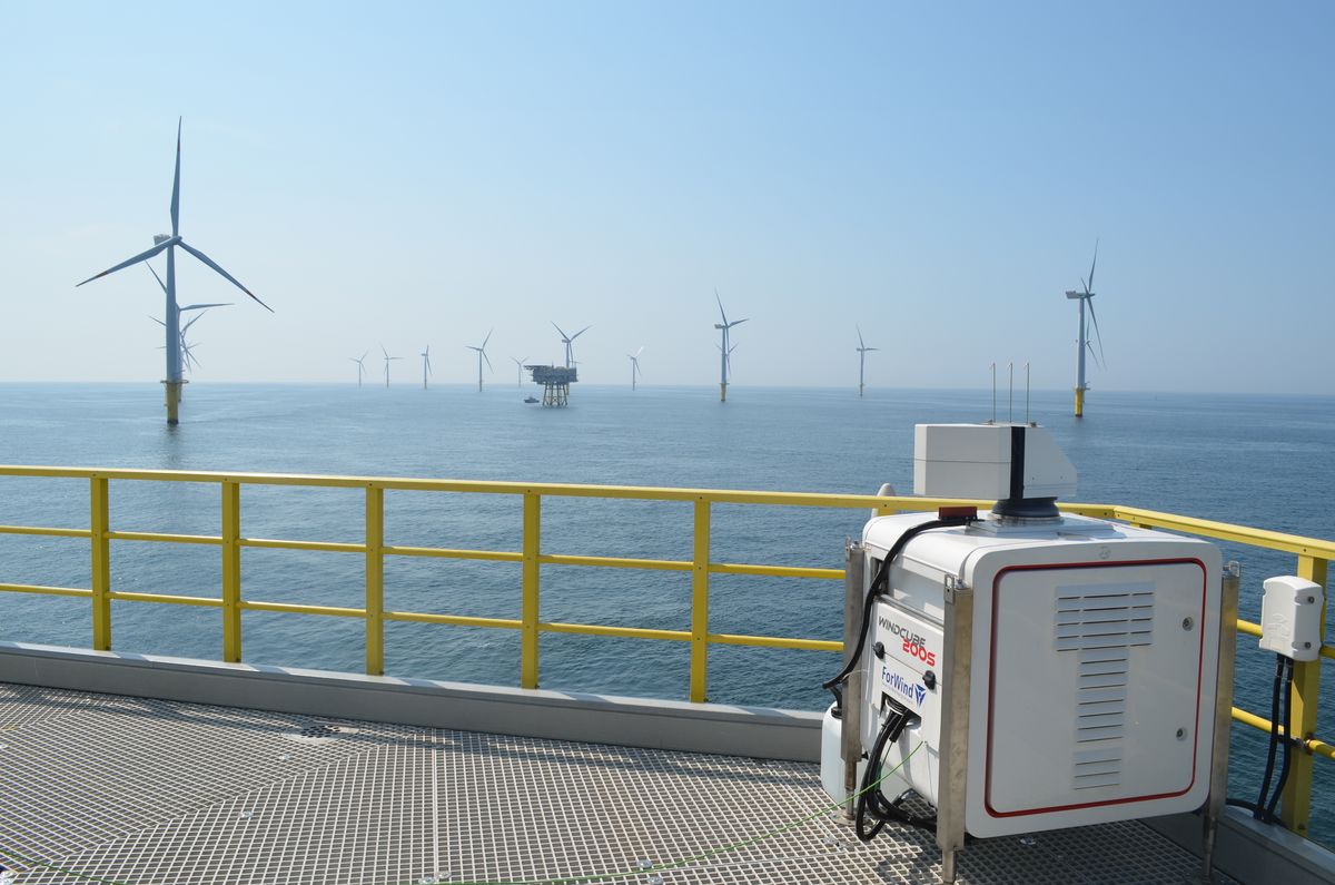
In order to measure the flow in and around wind farms and in the far wake of wind turbines, we operate three Leosphere WLS-200S long-range scanning lidar systems. This type of lidar is well suited to measure the wind over a large area, such as a wind farm, in a relatively short time frame. Another research area in which we employ these lidars is short-term wind forecasting.
Measurements of the wind turbine inflow
Apart from the investigation of wake effects, our research group also employs lidars for the measurement of wind turbine inflow. In order to understand the interaction between the wind turbine and the flow better, the wind imposing on the wind turbine has to be characterised. For measuring the inflow wind field in front of a turbine, we mainly operate a short-range SpinnerLidar. This lidar uses a fast (1 second) scan trajectory to quickly measure the wind field in front of the wind turbine. This information can be used to define wind field parameters such as wind speed, wind direction, wind shear and turbulence, which can be correlated with sensors on the wind turbine.
Measuring equipment
The Lidar & Wakes team within the research group Wind Energy Systems currently has a fleet of seven lidars, consisting of both pulsed and continuous wave lidars. Here is an overview of all lidars owned, their type and a short description.
| Lidar | Type | Number |
| Leosphere WindCube 200S | Long-range, pulsed | 3 |
| Leosphere WindCube 400S | Long-range, pulsed | 1 |
| DTU SpinnerLidar | Short-range, continuous wave | 1 |
| DTU WindScanner | Short-range, continuous wave | 2 |
The Leosphere WindCube Scan is a pulsed long-range lidar that can measure wind speeds with several kilometres of range at multiple distances simultaneously. The long range enables the measurement of large wind fields, e.g. capturing the inflow or wake effects of entire wind farms. The standard sampling rate is between 0.5 Hz and 10 Hz. Compared to the short-range lidars, the WindCubes have a lower spatial and temporal resolution, but make up for it with the much larger areas that they can cover. WE-Sys owns three WindCube200S lidars with a typical performance of 6 km to 8 km measurement range at 1 Hz and one WindCube400S with a typically achievable range of 12 km to 14 km at 1 Hz.
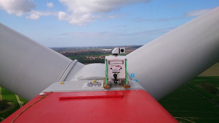
Leosphere WindCube on nacelle roof
The SpinnerLidar is developed and built by DTU Wind Energy and IPU upon existing continuous-wave Doppler-Lidar technology. It encompasses a commercially available ZephIR 300 Lidar with a custom 2D scan head to define 2D scanned wind fields with high spatial and temporal coverage. As its name suggests, it is designed for installation and operation from the spinner of a turbine. However, for practical reasons it is often more feasible to install it on top of the nacelle behind the rotor of a wind turbine. The current, upgraded version of the device has a scan head that consists of two 15° prisms rotating with different speeds which create a fixed ‘rosette figure’ scan trajectory that provides an optimal area coverage with high spatial resolution. The SpinnerLidar has a measurement range between 10 m and 150 m and a maximum sampling frequency of 500 Hz. The maximum wind field measurement frequency, i.e. the ‘refreshing rate’ of the rosette figure, is 1 Hz.
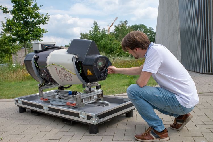
ForWind researcher Marijn van Dooren checks the SpinnerLidar
The short-range WindScanner is another device manufactured by DTU Wind Energy and IPU, also based on a modified ZephIR 300 lidar. The WindScanner is a ground-based continuous wave lidar that can be temporally and spatially synchronised as a pair or as a trio, which enables the measurement of 2D or 3D wind fields, respectively. The devices acquired by WE-Sys are two of the newer WindScanners with a 6" aperture, allowing for a double measurement range compared to the older 3" WindScanners. This means that the achievable measurement range is between 20 m and 300 m, with a maximum sampling rate of 500 Hz. The WindScanner encompasses a dual-axis prism scanning system which can focus and orient the laser beam freely within a 120° opening angle according to the user specifications by means of a focusing lens and two rotating prisms to steer the beam.
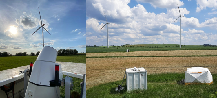
WindScanner in test field