NorthSat-X
NorthSat-X: The North Sea from space: Using explainable artificial intelligence to improve satellite observations of climate change
Duration: 3 Years (April 2021 until March 2024)
Contact:
Prof. Dr. Oliver Wurl
Tel.: +49-4421 944-228
Fax: +49-4421 944-140
E-Mail:
NorthSat-X
The North Sea from space: Using explainable artificial intelligence to improve satellite observations of climate change (NorthSat-X)
NorthSat-X is a project funded by the Lower Saxony Ministry of Science and Culture (MWK, Programme: Digitalization in Natural Sciences), conducted in collaboration with the German Research Centre for Artificial Intelligence GmbH (DFKI).
What is NorthSat-X about?
The North Sea coast is characterized by a high population density and a vigorous economic and recreational area. However, as a shelf sea, the North Sea is particularly sensitive to the impacts of climate change (Høyer and Karagali, 2016; Sterl et al., 2009; Jones and Reid, 2001). For instance, increasing water temperature, changes in freshwater fluxes, and salinity can lead to losses of fishing grounds in the North Sea (Beaugrand and Kirby, 2010).
Tasks and Objectives
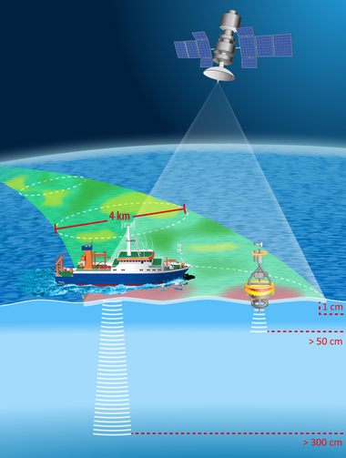
To better determine such changes and risks, the satellite-based monitoring of essential climate variables (ECVs) for coastal waters in NorthSat-X will be fundamentally improved with the help of machine learning methods. ECVs include, for example, sea surface salinity (SSS) and sea surface temperature (SST). The necessary reference data will be measured directly at the sea surface by deploying a remote-controlled catamaran (AutoCat). The design and installation of sensors on AutoCat are tasks in NorthSat-X. To achieve temporally and spatially matching remote sensing products and in-situ datasets, a collaboration with the Soil Moisture Ocean Salinity mission (SMOS) Expert Center (Institute of Marine Sciences, Barcelona, Spain) takes place.
Satellite observations have supported ocean monitoring in recent decades. However, there are still two significant challenges in the quality of satellite products for monitoring ECVs: (i) the poor calibration and validation of satellite remote sensing data with ground-based reference data and (ii) the degradation of data quality by landmasses limit the use of satellite products in coastal waters. This is particularly true for data acquired using microwave radiometers. But, since microwaves can penetrate clouds, they are particularly interesting for the North Sea region because cloud cover is a common weather condition. Comprehensive geostatistical analyses and the development and application of Explainable Artificial Intelligence (XAI) will be used to analyze the temporal and spatial variability of ECVs at the sea surface. The effects of wind speed, precipitation, and evaporation on SSS and SST will also be investigated. Of particular interest is the influence on the relationship between the ~10-20 µm thin layer at the sea surface (sea surface skin) and the underlying bulk water.
Project Partners
NorthSat-X consists of a multidisciplinary team of oceanographers, physicists, engineers, AI researchers, and remote sensing scientists.
Project Partners