More
Contact
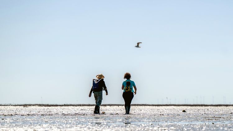
Silt, prile and sky as far as the eye can see: the Wadden Sea at low tide. University of Oldenburg / Daniel Schmidt
Geographer Thorsten Balke and his team are on a mission to protect intertidal zones and their dynamic ecosystems. The researchers have developed their own measuring devices to identify which areas are best suited as habitats for specific biotic communities. A visit to this unique landscape.
If you trudge across the mudflats off Horumersiel on the west side of the Innenjade tidal channel at low tide on a calm day, the first thing you notice is the peace and quiet: no noise from traffic or building sites, not even the sound of waves or birdsong – just the occasional call of an oystercatcher. Everyday life on land seems very remote out here in the middle of this huge expanse of sand and mud.
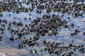
Further out, however, the scenery changes and an astonishingly diverse world emerges. Large, sharp-edged Pacific oyster shells protrude from the sludgy surface – just the odd one here and there at first, then in ever larger clusters that alternate with piles of mud and small pools of water for as far as the eye can see. The rough shells of the molluscs are covered with barnacles, tiny snails and even mussels. Fish larvae, transparent shrimp and small crabs dart across the puddles.
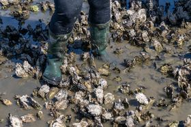
One wrong step here and you're ankle-deep in mud or scraping your shoes on sharp-edged oyster shells. "It's better to simply step directly onto the shells. Don't worry, the oysters won't mind," Dr Alejandra Vovides tells the two people accompanying her and technician Daniela Meißner on a field trip on this sunny day. The ecologist moves effortlessly across the difficult terrain. "I've been working in intertidal zones for ten years now," she explains. From mangrove forests in tropical countries like Mexico or Indonesia to the salt marshes of the River Clyde in Scotland, she has studied tidal flats and their ecosystems all over the world.
Vovides is a member of the Vegetation Ecology and Conservation research team, which is led by Prof. Dr Thorsten Balke and focuses on coastal wetlands that emerge for several hours at low tide. Sand, rock or fine silt form the substrate of these unique transition zones between land and open sea. This is a world of extremes, characterised by changing tides, fluctuating temperatures and salinity levels, powerful currents and a plentiful supply of nutrient sources. Depending on the climate and tidal currents, a variety of ecosystems thrive in these intertidal zones: mussel beds, seagrass meadows and salt marshes in the Wadden Sea; coral reefs, seagrass meadows and mangrove forests in the tropics. One thing they all have in common is that they are endangered by a variety of factors, including pollution, fishing and climate change.
Balke's team aims to bolster efforts to conserve and restore these biotic communities by finding out which environmental conditions are most favourable for which ecosystems. This involves measuring variables such as how long a specific zone is flooded, how strong the current is at high and low tide, with what force the waves churn the water over the flats and how extreme conditions become during a storm. To gather all this data, in 2018 Balke began developing small, low-cost sensors similar to the accelerometers in smartphones for long-term monitoring on the tidal flats. In the meantime, the team has calibrated and tested three designs for different applications. "Because existing hydrological sensors are too expensive and too big for our purposes, we decided to take matters into our own hands and refine the technology ourselves," says Balke. In an article published in 2024 in the journal Limnology and Oceanography Methods, Balke, Vovides and other researchers presented an updated design for their "Mini Buoys", together with an open-source app that analyses the gathered data.
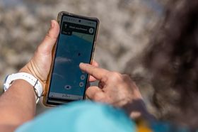
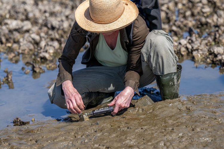
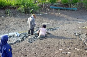
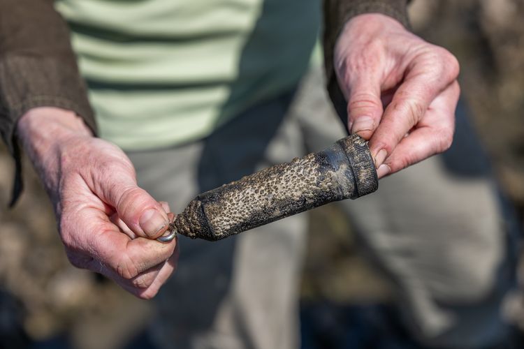
The sensors are now distributed across the tidal flats off the North Sea resort of Horumersiel – each well sealed in a black plastic tube around ten centimetres long. Today, Vovides and Meißner are on a mission to retrieve and replace four of the Mini Bouys out in the oyster beds and the shoreward mudflats. Their work is part of the German-Dutch SedWay project (Safeguarding the natural sediment processes in the Wadden Sea for biodiversity and people), which is led on the German side by Prof. Dr Bernd Siebenhüner, an environmental economist at the University of Oldenburg. The Lower Saxony Wadden Sea National Park Authority and the University of Groningen are also involved. "Our goal is to understand the hydrological landscape and create a fingerprint of the various habitats," Vovides explains as she makes her way across the oyster beds. The ecologist has positioned a total of 70 sensors at different locations between the islands of Terschelling in the Netherlands and Sylt in Germany, each of which has to be replaced every few weeks.
"The first sensor should be here somewhere," she says after a 20-minute march across mud and shells. According to the GPS, she's in the right location now, but all she can see far and wide is oysters. Only after a long search does she finally discover the small tube. A closer look reveals why the sensor was so hard to find: the black plastic casing is covered with tiny, grey barnacles that make it barely distinguishable from the surrounding oyster shells – an unexpected problem which Vovides hadn't yet encountered on her deployments in the salt marshes. "Now we'll have to do tests in the lab to determine whether this growth affects the buoyancy," she says.
Salt marshes are threatened by climate change
The Mini Buoys are attached by two keychain rings to a metal stake which is firmly lodged in the mud. At high tide, the sensors float upright in the water; at low tide, they lie more or less horizontal on the ground. In their study, the researchers were able to demonstrate that the devices record the desired data on the duration of tidal inundation and tidal current velocity with a high degree of accuracy. Now, thanks to a design update, they can also measure the force of the waves as they roll over the tidal flats.
The data will be fed into a Decision Support System (DSS) – a key result of the SedWay project, designed to help identify potential threats to the Wadden Sea ecosystems and plan measures for restoring lost biotic communities. One main focus here is seagrass meadows – an ecosystem of grass-like aquatic plants that thrive in water up to ten metres deep. Today, little remains of these biodiversity hotspots, which were apparently once widespread in the Wadden Sea. Seagrass meadows filter the water, bind large amounts of carbon dioxide and contribute to coastal protection. "Before the 1930s, the East Frisian Wadden Sea was probably home to extensive seagrass meadows," Balke says. Since the 1970s, however, the remaining populations have experienced a sharp decline, mainly due to the large amounts of fertiliser carried by rivers into the North Sea. "Only near Sylt are there still a few larger patches," he adds.
Despite the fact that nutrient levels have dropped again in certain areas, attempts to reintroduce seagrass have had mixed results, possibly because they were carried out at the wrong time or at sites where this plant cannot thrive. "Our aim is therefore to gain a better understanding of what the dynamics in the system should be: what current velocities allow seedlings to colonise, how long can a certain area remain dry?" says Balke, who faces similar questions in his research on mangrove forests – the highly diverse ecosystems consisting of salt-tolerant trees and shrubs that are typical of tropical intertidal zones. "I find it fascinating that the processes in these two systems are actually very similar," says the researcher, who has studied mangroves in Indonesia, Vietnam, Thailand and New Zealand, while always taking account of social factors that determine the success or failure of nature conservation measures. His doctoral thesis already focused on the hydrodynamic conditions needed for mangrove seedlings to grow on mudflats. Mangrove seedlings face the same challenges as plants such as marsh samphire in the salt marshes of the Wadden Sea – they need to take root within a relatively short time window in which the water level is low, and develop sufficient anchorage strength to avoid having their roots exposed or dislodged by the next storm.
The researchers refer to the period in which a germinating seed can take root undisturbed by tides as a "window of opportunity". How long it lasts can vary considerably at any particular location, because the tidal range is affected by the phases of the moon and the changing seasons. "With pioneer species in particular, it's important to know how long they need to become established," Balke emphasises. In a recently published study, Balke together with Vovides and other researchers determined that two species of a globally widespread genus of mangrove trees have the best chances of thriving when the window of opportunity is at least three days long. In lab experiments, the seedlings developed branched roots up to twelve centimetres long within 21 days once the three-day period had elapsed. A high salinity in the substrate delayed growth, however. Field experiments in a natural environment in Sumatra confirmed these results.
Plans are underway to restore 600,000 hectares of mangroves in Indonesia in the coming years
The researchers believe their study could contribute to optimising the location and timing of mangrove regeneration projects in Indonesia, where there are plans to restore a total of 600,000 hectares over the next few years. Natural seedling establishment would be considerably more cost-effective than the widespread – and frequently unsuccessful – practice of planting pre-grown seedlings. The team has identified the rainy season from November to February as the most propitious period for mangrove colonisation, as this is the time when water salinity levels are at their lowest and three-day windows of opportunity more frequent. "If the seeds are sown during this period, they have a better chance of thriving," Balke emphasises.
Whereas mangrove forests and seagrass meadows are endangered worldwide, oyster beds are now proliferating in the North Sea. These new arrivals to the mudflats have completely altered not just the ecosystem, but also the current patterns, because their textured nooks and crannies mean that they act as wave-breakers. The researchers plan to leave their Mini Buoys in the tidal flats off Horumersiel for a year in order to document several cycles of spring and neap tides, and perhaps even the odd storm. Meanwhile, Vovides and Meißner make their way to the next sensor, which is located a little closer to the shore, outside the oyster bed. "Let's see if it's still there," says Daniela Meißner. Mini Buoys can disappear, the two researchers explain: in areas that are more heavily frequented, curious holidaymakers sometimes make off with one of the devices. This time, however, the scientists are in luck, and after a few minutes they find what they're looking for – the small tube is lying half hidden in a puddle, buried under some algae.
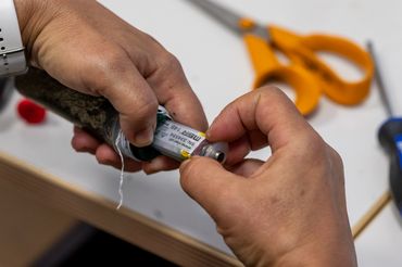
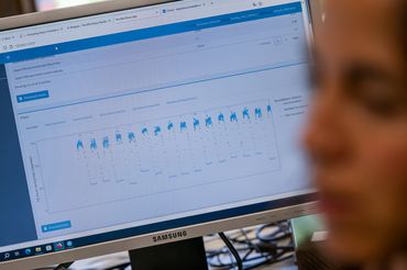
Back in the lab a few days later, Alejandra Vovides takes a closer look at the contents of the recovered sensors. She prises open the first of the encrusted plastic tubes to reveal the data logger inside: an oval-shaped plastic tube containing a circuit board with sensors and memory chips attached. She then loosens a tiny screw and connects a cable to the computer – et voilà, the raw data appears on the screen: a pattern of dots representing the tilt angle of the sensor relative to the horizontal plane over the relevant time period. The dots form a curve that rises and falls between two extremes. Apparently, the sensor has consistently recorded the rhythm of the tides over a period of several weeks – the strenuous hike across the mudflats has paid off.
This article appeared in the University's research magazine EINBLICKE.

This page contains automatically translated content.