Morphodynamics
Morphodynamics
Subproject 1: Holocene science and culture history
Morphodynamical Equilibrium states
![]()
![]() Contact: Hanz Dieter Niemeyer
Contact: Hanz Dieter Niemeyer
Tel.:+49-(0)4932-916-141
Dr. Heiko Westphal Tel.: +49-(0)4932-916-210 heiko.westphal[at]nlwkn-ny.niedersachsen.de
Area-balance Jade Bay
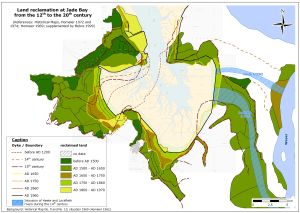
A new map, based on the historical maps No. 9 and 10 of the Lower Saxon Coast (HOMEIER 1969), summarizes land losses and impolderings since the 12th century in the Jade Bay area. Additional information is gained from the map of BEHRE (1999), particularly between Jade Bay and Lower Weser in the regions of Butjadingen and Stadtland (fig. 1). A comparison of land losses and land reclamation leads to the following results: The largest land losses of about 300 km² occur during the14th and 15th century. Afterwards from 1500 to 1650 land reclamation adds up to 150 km². Since 1750 land losses are at their minimum, whereas land reclamation remains constantly at a rate of about 20 km² per century from the 17th to the 20th century. 473 km² of the land area is lost since the 12th century while land reclamation adds up to 254 km². In total, a land loss of almost 220 km² has occurred around the Jade Bay since the 12th century. Morphodynamical equilibrium conditions A lot of researches about the morphodynamical equilibrium conditions at tidal coasts like the German Wadden Sea are done since many decades (amongst others O’BRIEN 1971; RENGER 1976; DIECKMANN 1985; NIEMEYER ET AL. 1995). System elements like cross-sections of tidal inlets, intertidal areas, etc. are related to hydrodynamic boundary conditions like tidal volume. These relations of the characterising elements quantify equilibrium states. The dynamic equilibrium states enforce steady adaptations to changing hydrodynamical impacts. For example powerful storm surges create land losses and increasing catchment areas being afterwards a mismatch with the ordinary hydrodynamics. Necessarily for a readjustment to a morphodynamical equilibrium sedimentation will reduce the basin volume until a new morphodynamical equilibrium state is established (NIEMEYER 1983). Analysis on morphodynamical equilibrium bases on relationships between significant parameters representing morphological features and shaping hydrodynamics, e. g. like cross-section of a tidal inlet and tidal volume of a basin by using statistically optimized functional relationships. Existence or non-existence of stable functional relationships indicate whether a coastal area has the state of morphodynamical equilibrium. Non-existence of morphodynamical equilibrium is a resilient indicator for morphological changes being necessary for a readjustment to morphodynamical equilibrium. Since these processes are always accompanied by erosion and accretion they are of importance for coastal protection, waterway stability and inland drainage. In the course of the Dutch-German research project WADE a number of functional relationships for morphodynamical equilibrium have been established and verified at the German North Sea coast for the East Frisian Wadden Sea and the Dithmarschen Bay (fig. 2) by Coastal Research Station (NIEMEYER ET AL. 1995). A major aim of this subproject is to establish similar functional relationships for morphodynamical equilibrium in the Jade Bay starting with the well-documented states of 1969 and 1999. Next steps will be to use data of earlier stages with lesser information density and finally even the historical maps of HOMEIER. The procedure to make maps with distinct information density has been developed by NIEMEYER (1995). The long-term comparisons between the distinct states will highlight if new morphodynamical equilibrium is established after the enormous land losses and readjustments in the Jade Bay since the Middle Ages. References BEHRE, KARL-ERNST (1999): Die Veränderung der niedersächsischen Küstenlinien in den letzten 3000 Jahren und ihre Ursachen, In: Probleme der Küstenforschung im südlichen Nordseegebiet (26), 9-33. DIECKMANN, REINHARD (1985): Geomorphologie, Stabilitäts- und Langzeitverhalten von Watteinzugsgebieten der Deutschen Bucht, In: Mitteilungen des Franzius-Instituts für Wasserbau und Küsteningenieurwesen der Universität Hannover, Heft 60, 133-361. HOMEIER, HANS (1962): Historisches Kartenwerk 1: 50.000 der niedersächsischen Küste, Jahresberichte Forschungsstelle Norderney, 1961, Band XIII. HOMEIER, HANS (1969): Der Gestaltwandel der ostfriesischen Küste im Laufe der Jahrhunderte. Ein Jahrtausend ostriesischer Deichgeschichte, S. 2-75, In: Ohling, Jannes (Hrsg.): Ostfriesland im Schutze des Deiches, Bd. 2, 678 S. HOMEIER, HANS (1972): Niedersächsische Küste, Historische Karte 1:50.000, Nr. 9, Niedersächsische Wasserwirtschaftsverwaltung (Hrsg.), Norderney. HOMEIER, HANS (1974): Niedersächsische Küste, Historische Karte 1:50.000, Nr. 10, Niedersächsische Wasserwirtschaftsverwaltung (Hrsg.), Norderney. NIEMEYER, HANZ DIETER, ROLAND GOLDENBOGEN, ERNST SCHROEDER UND HANS KUNZ (1995): Untersuchungen zur Morphodynamik des Wattenmeeres im Forschungsvorhaben WADE, In: Die Küste (57), 65-94. O'BRIEN, M.P. (1971): Notes on tidal inlets on sandy shores, Hydraulic Engineering Laboratory, College of Engineering, University of California, Berkeley, 51 S. RENGER, EBERHARD (1976): Quantitative Analyse der Morphologie von Watteinzugsgebieten und Tidebecken, In: Mittelungen des Franzius-Instituts für Wasserbau und Küsteningenieurwesen der Universität Hannover (43), 1-160.