Mesoscale modelling
Mesoscale modelling
Mesoscale modelling of the wind resource & wind power prediction
Mesoscale models are atmospheric flow models that are based on the same basic equations as global weather and climate models, for example. While the latter are calculated globally and have correspondingly coarse grids, mesoscale models concentrate on smaller regions (e.g. Central Europe, Germany, Lower Saxony) and have a significantly higher spatial resolution, typically in the range of a few kilometres. Unlike global models, mesoscale models can also capture smaller-scale atmospheric phenomena, such as local wind systems. They are therefore ideal for determining the regional wind resource.
ForWind uses the mesoscale model WRF (Weather Research and Forecasting Model). This freely available model is used by numerous users worldwide, especially in research. At ForWind, it is mainly used to analyse the wind potential at various locations. For example, a wind and stability atlas for the southern North Sea (WASA) was created based on WRF simulations for the years 1993-2012. Results show that wind and atmospheric stability over the southern North Sea are spatially heterogeneous, with unstable stratification dominating. Contrary to what is generally assumed, the turbulence intensity over the North Sea is not constantly lower than over land, but actually slightly higher in the winter months due to the stratification effect.
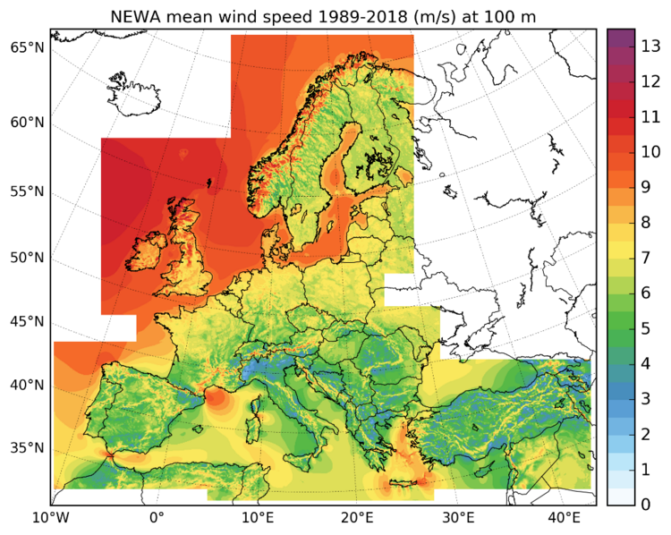
In the international NEWA research project, the wind conditions across Europe (see also figure) were simulated in detail for the last 30 years (1989-2018) at a spatial resolution of 3 km, thus creating a New European Wind Atlas, which is to be used as a basis for planning the use of wind energy in Europe. In extensive preliminary work, various model settings were tested and results compared with measurements. In addition, ensemble simulations were carried out to estimate the uncertainty of the data in the wind atlas based on the model settings.
In a further study, an existing wind farm parameterisation in WRF was used to investigate the influence of offshore wind farms in the North Sea on the wind climate. The parameterisation was further developed to take into account the influence of wind farm layouts.
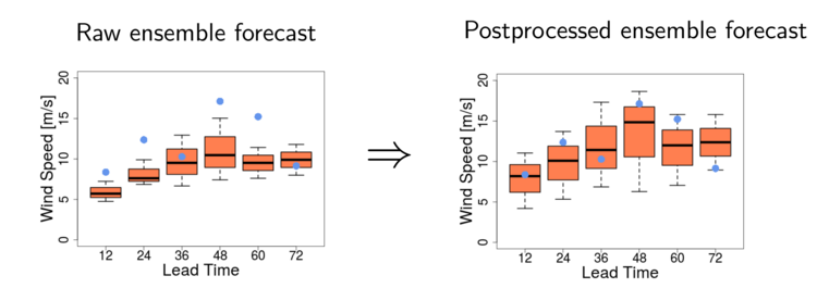
Wind power forecasts have become indispensable in many countries around the world for integrating large amounts of wind power into the electricity grid. The calculation methods and quality have improved greatly over the years, although extreme forecast errors or extreme situations (e.g. very high wind feed-in) continue to cause problems. The development of ensemble methods in numerical weather prediction (NWP) has long offered weather forecasters the opportunity to assess the forecast quality based on the spread of ensemble members generated by slight perturbations of the initial conditions during model initialisation. The spread of the ensemble is often too small in the short-term range relevant for wind power forecasting or exhibits systematic errors. These deficits can be eliminated by using univariate or bivariate calibration methods.
In the Baltic I research project, various calibration methods were developed and their behaviour tested for different locations. It was shown that onshore sites in complex terrain particularly benefit from calibration if both wind components are calibrated simultaneously. It has also been shown that different ensemble models can be calibrated differently when using the same method. Why such sensitivities occur is a subject of current research, as is the simultaneous calibration of solar power and wind power forecasts.